A biking and hiking view of the FATS
The Forks Area Trail System near North Augusta is one of the most popular mountain bike destinations in South Carolina’s Midlands Region, and for good reason.
About 37 miles of perfectly …
This item is available in full to subscribers.
Subscribe to continue reading. Already a subscriber? Sign in
Get 50% of all subscriptions for a limited time. Subscribe today.
Please log in to continue |
A biking and hiking view of the FATS


The Forks Area Trail System near North Augusta is one of the most popular mountain bike destinations in South Carolina’s Midlands Region, and for good reason.
About 37 miles of perfectly maintained trails ranging in difficulty cut through the rolling hills and valleys of the Savannah River Valley in Sumter National Forest.
A total of 6 loops, varying from 4 to 8 miles, each have their own uniqueness to them.
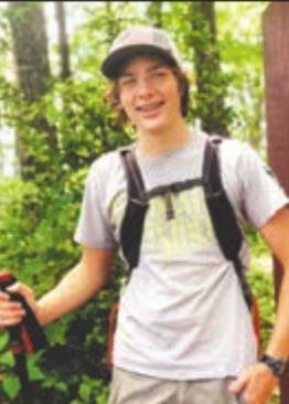
I’ve been hearing about the Forks Area Trail System, or FATS, for some time now. So, I decided to make the hour drive to see it for myself on a warm June morning.
I decided the start at the Main Southern Trailhead, where 4 of the trails start first. Upon arriving I found a big parking area with lots of cars already there. A bathroom and picnic tables are at the trailhead.
I wanted to start out on one of FATS two easier trails, Brown Wave or Skinny, but couldn’t decide which one, so I asked a friendly group of mountain bikers for a recommendation, they said Skinny is the best to start. Sounds good to me, I pulled out my bike, buckled up my helmet, threw on my backpack, and I started down the trail.
THE FIRST QUARTER mile was the connector trail, after that, the 2 easy trails split to the left and the two harder trails at the South trailhead headed to the right. The two other trails are The Great Wall, a bit of everything trail with harder climbs and some more technical features, and Deep Step, arguably the hardest trail according to riders, with lung busting climbs and blazing fast descents.
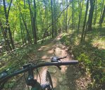
After another quarter mile, Skinny Trail split off to the right, and I flew down it. The trail twisted and turned down a valley on a narrow trail. The trail wasn’t too steep and was very manageable for even the most novice mountain biker like myself but I learned a valuable lesson very quickly.
I took a turn too fast and too wide and ended up smacking my front tire straight into a big pine. Somehow I walked away scratch-free and miraculously my bike was ok. I continued on a bit slower, especially around the turns.
OVER THE NEXT couple miles, the trail crossed a power line clearing several times. In either direction you can see steep hills and other trails crossing the clearing. The trail cut through valleys and along hillsides with enough turns to confuse anyone. Although the trail constantly rises and falls, the climbs were easy enough and the descents were still fast and fun.
Around mile 3, the trail made a straight shot towards the river along the side of a hill. It was fast, super flowy and fun for a mile all the way to the bottom. Unfortunately every down turns into a climb.
The trail turned back before the river is visible and begins climbing for the next 2 miles. The climbing isn’t too tough, but it’s relentless. Soon, I made it to the turn off to Brown Wave, another easy 6 mile loop but I didn’t have it in me.
Brown Wave gets a lot closer to the river and is also a blast from what I hear.
THE LAST MILE was just me climbing back to the parking lot. Along the way, the Pines let up to give way to a beautiful view of the surrounding valleys. A bit further and I was back at the parking lot. Next, I wanted to visit the Northern Parking lot 3 miles up the road where an additional 2 loops start. To get there you have to drive down a gravel service road, but it shouldn’t be a problem for any car. The parking lot was a lot smaller, with no amenities.
THE TWO LOOPS were each 4 miles, Big Rock and Tower, both are about the same difficulty with hard climbs and some optional technical lines for more advanced riders. Instead of doing a whole loop, I decided to bike back up the service road to where Big Rock crosses the road. It was a tough .7 miles and once I was at the top, my legs felt like jelly. The climb was well worth it though, because I now had 200 feet of elevation to go down.
I flew down the 2 mile section of trail as it hugged the steep valley walls. It wasn’t too technical and most anyone could do the trail going down. Towards the bottom the trail was a straight shot down with water bars along the way. You better believe I got plenty of air on those water bars.
At the bottom there was a short but brutally steep climb to the parking lot. I ended up walking it. When I made it back to the car, I was exhausted, but satisfied. I had a blast at FATS and it was well worth the drive. The trails were super well built and fun with something for everyone.
If mountain biking isn’t your thing, I saw just as many people walking as biking and it would make for a fun, pretty, and mostly easy walk.


Comments
No comments on this item Please log in to comment by clicking here