Hiking along the Lake Moultrie Passages’ dikes
Lake Moultrie is a fisherman’s paradise.
It covers almost 100 square miles in Berkeley County and it’s the 3rd largest lake in the state.
Fishermen come from all over to catch some of …
This item is available in full to subscribers.
Subscribe to continue reading. Already a subscriber? Sign in
Get 50% of all subscriptions for a limited time. Subscribe today.
Please log in to continue |
Hiking along the Lake Moultrie Passages’ dikes


Lake Moultrie is a fisherman’s paradise.
It covers almost 100 square miles in Berkeley County and it’s the 3rd largest lake in the state.
Fishermen come from all over to catch some of the lake’s catfish, gar, and bass. I wasn’t interested in the fish. I wanted to hike the lake’s vast dike system and mark off the Lake Moultrie Passage on my quest to see all of the Palmetto Trail.
THIS IS SOUTH Carolina’s cross-state hiking trail that will eventually stretch from the mountains to the sea.
On an early April morning, my friend Chloe Terry and I paid the lake a visit.
She picked me up bright and early to make the trek to Lake Moultrie. A quick drive down the interstate and we were in Moncks Corner, then Francis Marion National Forest. Everything was flat and straight with no lake in sight, just trees.
We made it to the parking area where the Lake Moultrie Passage begins. We wanted to start with the iconic open water view of the lake.
The wide trail cuts through floodplains filled with an assortment of pine and softwoods. A gulley and creek run parallel to a perfectly straight trail.
The weather was sunny and 65 degrees. The air was still but wasn’t humid for a change. After about a half mile we crossed a railroad and continued past a fence.
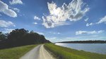
Through the fence we could see the 36 foot tall grassy dike towering just in front of us holding the lake back from flooding.
We climbed the steep dike to the top. It was worth it.
The second the lake came into view, a gust of wind almost knockied us back. The lake was as choppy and violent as the ocean. We could barely make out the land on the other side. To the side, we could see the gravel and grass dike extend 5 miles to the town of Bonneau Beach. The other way the dike extended miles to Pinopolis.
We sat down to take pictures and enjoy the view.
THE WAVES CRASHED into the boulders, trying to break through the dike. We fought the 25 mph wind the whole time, it even blew off my hat. The sky darkened with clouds, then cleared and was sunny.
When it was time to climb down the dike into the floodplain, the air once again became perfectly still. It’s amazing that the dike could not only hold back the lake but also completely block the wind.
BACK AT THE car, we decided to take a quick detour from our Lake Moultrie tour to visit Wadboo Swamp in Francis Marion National Forest.
We drove to the end of a gravel road to the trailhead and started hiking into woods similar to those below the dike. The ground was blanketed in green ferns.
A quarter mile along the Wadboo Swamp trail, part of the 47-mile Swamp Fox Passage of the Palmetto Trail, the dirt trail ended and a boardwalk began.
Pines and poplars turned to cypress and the ferns turned to swamp.
THE BOARDWALK CROSSED Wadboo Creek where a kayak launch lay below the bridge.
Across the creek, the boardwalk ended and a narrow path picked up. Everywhere we looked we saw lizards, frogs and even a furry red poisonous caterpillar. About a mile in, we decided to turn back.
Our next stop was Bonneau Beach on the lake.
The town reminded me of Edisto Beach.
Cute houses lined the streets. People drove around in golf carts without a care in the world and a restaurant sat right on the edge of the lake.
The road ended in a asphalt area right on a beautiful open water view of the lake. Parking, a boat ramp, and a public beach all were right there. It was the type of place I would go on vacation.
We visited a section of the Lake Moultrie east dike and hiked in about 10 minutes. The dike ran near a narrow canal with houses and docks giving access to the lake.
It was already 5 o’clock but we wanted to make one last stop.
WE DROVE UP the lake towards St. Stephens to visit the old Lake Moultrie Canal connecting the lake to the Santee River. The canal is protected by the Canal Wildlife Management Area.
We parked at the Amos Lee Gourdine boat ramp and hiked along the dike. After a few hundred feet, the dike bends through the forest and reveals the canal.
It was one of the most peaceful places I have visited. The wide canal was surprisingly calm, especially after seeing the raging waves on Lake Moultrie.
One either side of the canal was a wide grassy area with gravel trails running parallel to the canal about 50 feet back. Familes were scattered along the banks fishing and picnicking. We could hear the sounds of gentle waves hitting the banks, birds overhead, and happy people. We sat by the bank to enjoy it all – the perfect end to a perfect day.
Lake Moultrie might be known for its fishing and boating but we discovered there’s much more to see.
The 26.2 mile Lake Moultrie Passage of the Palmetto Trail follows along the lake’s large system of dikes, by the open water, through Bonneau Beach, through the Canal WMA, and by much more we didn’t have time to see.
It’s worth the 90-minute drive to hike or bike this manmade wonder.


Comments
No comments on this item Please log in to comment by clicking here