Taking a stroll through the Great Wateree Passage
THE WORLD OUTDOORS
What if you could hike across South Carolina?
What if you could go all the way from our pristine coast to the rolling mountains of the Upstate?
…
This item is available in full to subscribers.
Subscribe to continue reading. Already a subscriber? Sign in
Get 50% of all subscriptions for a limited time. Subscribe today.
Please log in to continue |
Taking a stroll through the Great Wateree Passage


THE WORLD OUTDOORS
What if you could hike across South Carolina?
What if you could go all the way from our pristine coast to the rolling mountains of the Upstate?
Along the way, gaining experiences that will last a lifetime.
Imagine the most unique and fulfilling tour you could possibly take of South Carolina.
That tour is called the Palmetto Trail. It stretches 500 miles going through swamps, vast lakes, towns, mountains and even down the steps of the state capitol building.
Right now, you can hike 350 miles of it through 23 unique sections, ranging from just a couple of miles up to 50.
The Palmetto Conservation Corps have been hard at work to complete it since 1994.
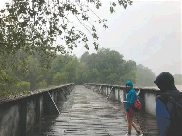
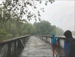
I’VE BEEN ITCHING to do another section of the PT, most specifically the Wateree Passage. The 11.4-mile section is easily one of the most diverse sections of the trail. It takes you through floodplains, over steep hills and across the Wateree Swamp and River.
The section starts at Poinsett State Park in Wedgefield and ends at a trailhead near Eastover.
After a lot of convincing, my friends Chloe and Noah agreed to go with me. We all met at Poinsett State Park around 9:30 am on a cool August morning to begin our hike.
We had prepared lunch and brought along plenty of water.
The first mile of the hike took us through a floodplain inside Poinsett State Park. We listened to music and enjoyed the morning as we hiked along. The trail through the park was nice, wide, and well kept.
After another mile, we crossed a little bridge and intersected a dirt road.
Leaving the state park, we had to walk along a blocked off service road for the next mile. Towards the end of the road, a small pond could be seen beside the road. Of course, I investigated and took some pictures.
We reached the end of the road about 5 minutes later. The trail continued up a mountain that seemingly came out of nowhere.
We stopped at a nice shelter with benches, a table, sink, and a working manual water pump for a quick snack before starting up the bluff.
For the next 2.5 miles, the trail continued up and over small hills with a steep ravine to the side at points.
AT THE HIGHEST point, Molly’s Bluff, you can peer through the trees to the Wateree Swamp about a hundred feet below.
In the distance, we could make out the formerly named SCE&G plant looming over the swamp.
We heard you could see Columbia from the bluff, but all we could see were rain clouds. With the increasing rainfall, we hurried the half-mile down the mountain to where the trail meets the old S.C. Railroad.
The trail crosses the Wateree Swamp on the raised 5-mile section of track. The Palmetto Conservation Corps converted the track’s 10 trestles into safe and wide boarded bridges.
After about a mile of walking along the extremely straight and slightly overgrown trail, we reached Sumter Junction.
At the junction, the railroad from Columbia to Sumter splits off to head for Camden.
Its a really cool area I wish we had more time to explore. But, by now it was raining and all we wanted to do was to keep walking.
WE KEPT UP high spirits while soaked for a couple of miles before we reached the 5th trestle Cottonmouth Bridge. After crossing the bridge, I happened to look down just in time.
I was greeted by a huge cottonmouth snake.
It slithered back into the swamp almost as fast as I jumped backwards. It was another reminder that most animals are more scared of you than you are of them.
We paid a lot closer attention to the ground after that. A couple of miles later, we finally reached the Wateree River. There I pulled my phone out and took a couple of pictures before moving on.
Soon, the trail intersected active railroad tracks. After crossing, the rails to trails section ended and the narrow trail snaked up above the railroad and off into the woods.
The trail turned into a dirt farm road. We followed that road for another 1/2 mile or so before intersecting US-601 near Eastover.
For our final 3 miles, the trail ran into the woods within earshot of the highway. Then, the rain subsided and the sun’s rays peaked through the trees on our final stretch.
FINALLY AFTER 11.4 miles and 6 hours, we finished our hike at the Farmstead Road Trailhead. Thankfully, my car was there waiting for us.
Right now the longest continual section of Palmetto Trail starts at Farmstead Road and ends 169.6 miles away at the Intercoastal Waterway in Awendaw.
We had a great hike and the Wateree Passage is my new favorite section of the PT in the Midlands. If you’re not up for such a long hike, spend some time hiking at Poinsett State Park.
It’s just an hour away and has something to do for any age.
Whatever you decide to do, make sure to get outside and see what the Midlands has to offer.


Comments
No comments on this item Please log in to comment by clicking here